Methow valley backsliding, King & Pierce counties not up to spec
Just to be clear, the title applies to current smoke levels.
Here is this morning's satellite picture showing areas of smoke (clouds are whiter, smoke is light gray).
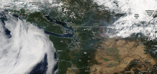 Light smoke, mostly from BC drifting over the Puget Sound lowlands is causing some areas of Moderate air around the central Sound. Chelan and Okanogan County fires are fouling up the Methow and nearby communities but thankfully haven't returned those areas to the conditions they saw last week.
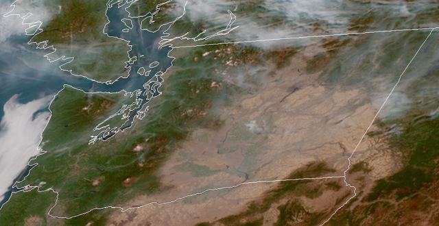
Though you can't see it clearly, Vancouver Island fires are sending a plume that is sitting offshore waiting to come inland when the winds turn west/ southwest on Wednesday. The Canadian FireWork model seems to be the only one getting most of these details right, so here's the prediction for Wednesday afternoon (left) and Thursday morning (right), as the winds shift:


What this means for western WA
It is possible that air will be compromised in southwest WA and the central Sound on Wednesday, but we're not expecting anything worse than Unhealthy for Sensitive Groups. Expect Good air by Thursday morning.
Eastern WA forecast
Except for areas close to major fires, we don't expect large-scale intrusions of smoke on Wednesday. Northeastern WA including Spokane might see a few hours with Unhealthy for Sensitive Groups on Thursday caused by transient plumes, but that will be followed by mostly Good air.
Please check back on Thursday for a Labor Day weekend smoke forecast.
Finally, we'd like to thank our readers for responding to the survey posted yesterday, and for flooding us with notes of appreciation. We will do our best to incorporate your suggestions into the smoke blog and forecasts. Feel free to complete the survey if you haven't already.
Here is this morning's satellite picture showing areas of smoke (clouds are whiter, smoke is light gray).

Though you can't see it clearly, Vancouver Island fires are sending a plume that is sitting offshore waiting to come inland when the winds turn west/ southwest on Wednesday. The Canadian FireWork model seems to be the only one getting most of these details right, so here's the prediction for Wednesday afternoon (left) and Thursday morning (right), as the winds shift:


What this means for western WA
It is possible that air will be compromised in southwest WA and the central Sound on Wednesday, but we're not expecting anything worse than Unhealthy for Sensitive Groups. Expect Good air by Thursday morning.
Eastern WA forecast
Except for areas close to major fires, we don't expect large-scale intrusions of smoke on Wednesday. Northeastern WA including Spokane might see a few hours with Unhealthy for Sensitive Groups on Thursday caused by transient plumes, but that will be followed by mostly Good air.
Please check back on Thursday for a Labor Day weekend smoke forecast.
Finally, we'd like to thank our readers for responding to the survey posted yesterday, and for flooding us with notes of appreciation. We will do our best to incorporate your suggestions into the smoke blog and forecasts. Feel free to complete the survey if you haven't already.

Comments
Post a Comment